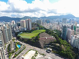
Quarry Hill (Hong Kong)
Appearance
| Quarry Hill, Hong Kong | |
|---|---|
| 採石山 | |
 View of Quarry Hill | |
| Highest point | |
| Elevation | 106.8 m (350 ft) |
| Coordinates | 22°18′57″N 114°11′03″E / 22.315775°N 114.184042°E |
| Geography | |
Location of Quarry Hill in Hong Kong[clarification needed] | |
| Location | |
Quarry Hill (Chinese: 採石山) is a hill east of Ho Man Tin near the east coast of the Kowloon Peninsula in Hong Kong where present-day Ho Man Tin (South) Estate[1] is located. Its peak is 106.8 metres (350 ft) high. The area was once zoned as the Shek Shan Resettlement Area (石山徙置區), above Kau Pui Lung Road and near present-day Lok Man Sun Chuen.
History
[edit]At the time of the 1911 census, the population of Shek Shan was 277. The number of males was 178.[2]
Streets and places in Quarry Hill
[edit]- Sheung Shing Street
- Sheung Lok Street
- Sheung Wo Street
- Shing Lok House
- Fat Kwong Street
- Ho Man Tin Estate
- Ho Man Tin (South) Estate
- Ho Man Tin Plaza
- One Homantin (under construction)
- Mantin Heights
- Celestial Heights
Education
[edit]
Educational institutions in Quarry Hill include:
- Chan Sui Ki (La Salle) College
- Hoi Ping Chamber of Commerce Secondary School
- St. Teresa Secondary School
- Y.W.C.A. Hioe Tjo Yoeng College
- Wa Ying College
Public services
[edit]Community facilities
[edit]- T.W.G.Hs. Wong Cho Tong Social Service Building
- SAHK LOHAS Garden
- Sheung Shing Street Park
Transport
[edit]References
[edit]- ^ "何文田站非「從前」何文田 80後考證 原名老龍坑 - 20161022 - HOT PICK". 明報OL網 (in Traditional Chinese). Retrieved 2019-11-25.
- ^ Hase, Patrick (1996). "Traditional Life in the New Territories: The Evidence of the 1911 and 1921 Censuses" (PDF). Journal of the Royal Asiatic Society Hong Kong Branch. 36: 83. ISSN 1991-7295.
- "Colony of Hong Kong 1922 (hillSheet 5)". Hong Kong Public Libraries - Multimedia Information System. London:War Office. 1922. Archived from the original on 2011-07-21. Retrieved 2008-11-01.
Wikimedia Commons has media related to Quarry Hill, Hong Kong.

